
For a year, photographer and history researcher Estelle Slegers Helsen has wandered around Lochaber in the footsteps of W.S. Thomson MBE (1906-1967). Estelle has made a series of remakes roughly 70 years after Thomson originally depicted the landscape. She has talked to local people along her journey and now Estelle will be taking you to the different places in Lochaber. This is article #7.
Loch Leven and Ballachulish Village
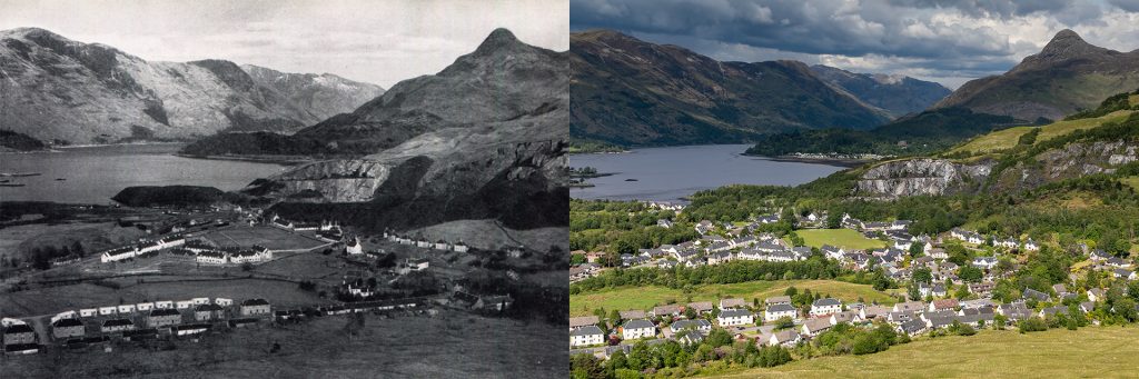
W.S. Thomson climbed about 150 metres up the east flank of Beinn Bhàn to photograph West and East Laroch, now known as Ballachulish, or Baile a’ Chaolais, meaning village by the narrows. The narrows refer to South Ballachulish, the original settlement, at the ferry crossing, replaced in 1975 by a bridge.
Much of the Ballachulish’s history and development, especially East and West Laroch, on each side of the River Laroch, is closely entwined with the rise and fall of the well-known slate quarries, of which the East Quarry is featured in Thomson’s picture.
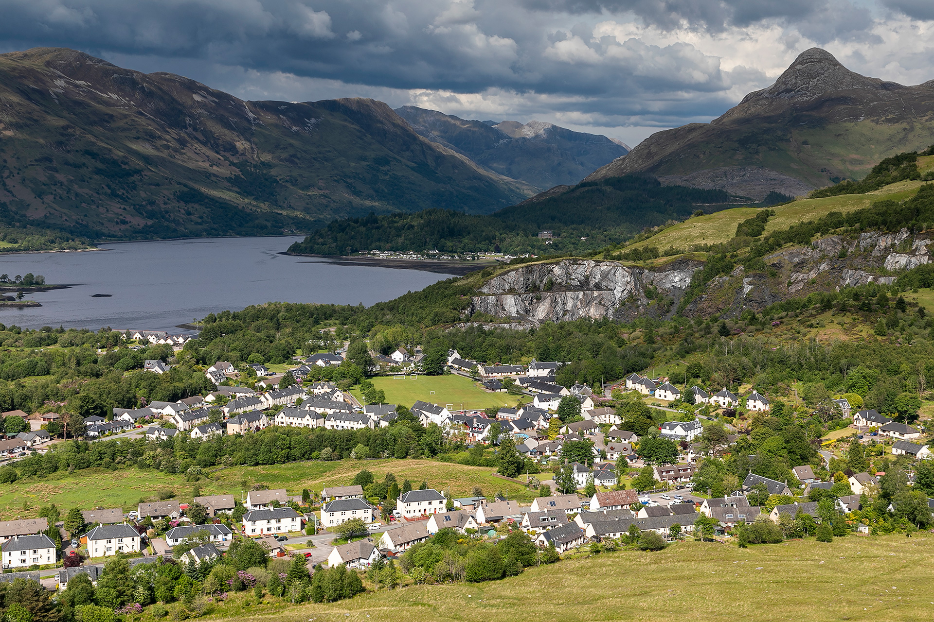
Overall, after 70 years, more trees contrast with more white dwellings in a sunny landscape. Building developments have boomed, leaving some rough land bordering the river, in the centre of the picture, and the wild slopes towards the deserted slate quarry, on the right.
Nowadays, traffic primarily takes the A82, which in this area runs close along the shore of Loch Leven. When Thomson took his black-and-white picture at the end of the 1940s or the beginning of the 1950s, the main road from South Ballachulish went inwards, following the villages’ triangular shape, making a 90-degree turn at Laroch Bridge and then taking another sharp turn behind the quarry before heading to Glencoe.
Let us follow this road and discover what has changed.
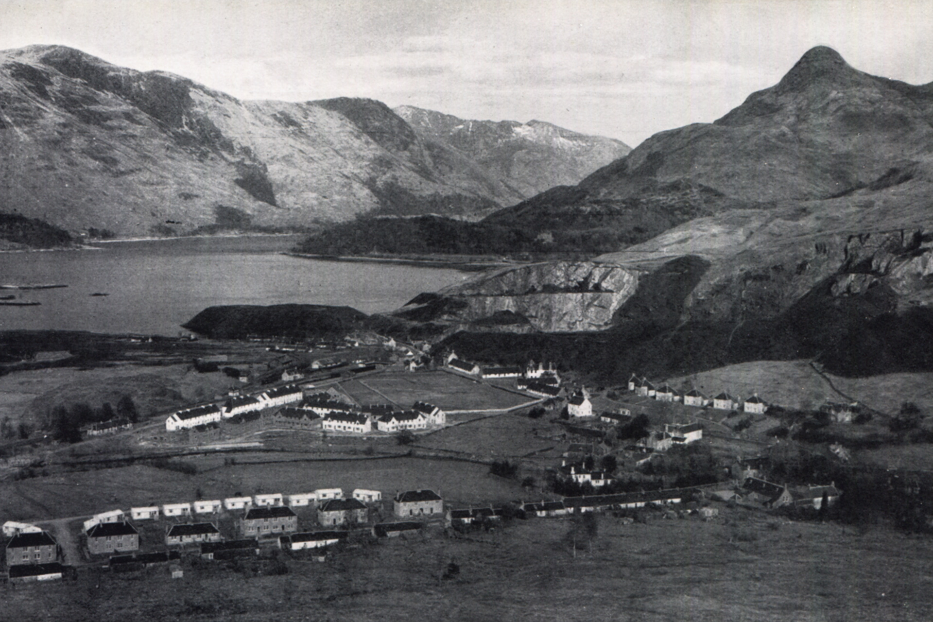
West Laroch was a one-street community with, on the south side, a series of single-storey cottages housing quarry workers. A few of these dwellings, located near the bridge, have survived. Opposite, a dozen semi-detached two-storey buildings face the road. Behind, you can see a row of prefab houses built in 1947 by the Argyll County Council. Rosalin MacDonald spent her childhood at 10 Leven Terrace, now 1 Croft Road, the house on the far right. She says: ‘These new post-war emergency homes had the most modern comfort with running water, an inside toilet and a washing machine.’
‘Unfortunately, three small burial cairns were destroyed when the field was cleared building the houses,‘ adds Rosalin, one of the co-founders of the Glencoe Heritage Trust. ‘On the left edge of the picture, you can see a part of Eilean Munde, or The Burial Island, maintained by our trust. The island in Loch Leven is home to over 300 graves from many clans.’
The single-span Laroch Bridge connects east and west and was built in 1785 when the military road from Stirling to Fort William, dating from 1752 and initially passing via the Glen Coe Devil’s Staircase and Kinlochleven, was re-routed via Glencoe and Ballachulish Ferry.
Another series of 12 semi-detached worker’s cottages, named Argyll Cottages, can be seen on the right on a bank above the road. Further along, opposite the recreation ground, the area of well-kept grass in the middle, stands the Drill Hall. In 1914, this was the base for the “F” Company, 8th battalion Argyll & Sutherland Highlanders. The building, dated circa 1870, was originally the Mechanics Institute, located at the centre of a model housing estate of quarriers’ cottages.
‘Slate quarrying started in 1693 initiated by Mr Stewart of Ballachulish,’ says Iain Dickie, who I met at one of the talks I held during my visits to the area, and who has a fine collection of local postcards. ‘Within a century, the quarries employed more than 300 men. At the start of the 20th century, a workforce of 600 produced 26 million slates yearly, transported from Loch Leven, a sea loch, to England, Ireland and America. There was a smaller West Quarry and a bigger East Quarry, with a quarry face nearly a mile long.’
A maze of local tramways transported the slate ready for export and dumped the slate waste, creating the black hill to the left of the quarry, sliding into the loch. The hill was levelled, creating a small tree-covered peninsula called Alltan Mhic Aiodh.
The East Laroch Quarry was the last of the Ballachulish quarries to be worked and closed suddenly in 1955, bringing a devastating blow to the community. The quarry left a permanent scar on the landscape, visible from far away.
In the centre of the picture, you can see Park Road, another housing estate for quarry workers, then in a mix of white and grey walls, now all painted white. The River Laroch meanders along at the front but 70 years later is hidden in trees and scrub.
Ballachulish was also the terminus of the Callander and Oban Railway branch from Connel Ferry, which opened in 1903. At the signal box, pictured just above the middle of the three white housing blocks, cargo traffic split off to the left, and passenger trains went straight on. All traces of the railway line, which closed in 1966, are gone, except for the old terminus station, now Ballachulish Medical Practice in East Laroch.
Tom Meadhoin, Mam na Gualainn and Beinn na Caillish, on the north side of Loch Leven and the characteristic Pap of Glencoe (Sgorr na Cìche) on the opposite flank, remain the natural backdrop, accompanied by typical Scottish clouds.
Move the slider to discover what changed.
Then (left) – Late 1940s © W.S. Thomson – Loch Leven and Ballachulish Village. Published in Let’s See Glen Coe and Loch Leven (Corpach edition), p.25
Now (right) – June 2022 © Estelle Slegers Helsen – Loch Leven, the Pap of Glencoe, the old East Quarries and Ballachulish Village from the east flank of Beinn Bhan. Published in Travel in Time. Lochaber, Scotland (New Traces, 2022), p. 51

Travel in Time – Lochaber Series is supported by the West Highland Museum and the Year of Stories 2022 Community Stories Fund.
Estelle has published a 64-page book with 30 side-by-side then-and-now pictures, which you can find in local shops or buy online. More information available here.