Photographer and historical researcher Estelle Slegers Helsen has been wandering around Lochaber in the footsteps of the Scottish photographer W.S. Thomson MBE (1906-1967). Since 2021, she has taken photographic remakes for roughly 75 years after Thomson initially captured the landscape and has talked to local people along her journey. This is article #26 and #27.
Around 1950, Mallaig was a bustling harbour. Fishing boats were crammed in multiple rows against the pier to unload their catch. The fish, foremost herring, was loaded directly into railway wagons on the opposite quay, ready to be taken south. Steamers transported locals, mail and tourists to and from the isles of Skye, the Inner and Outer Hebrides.
Village
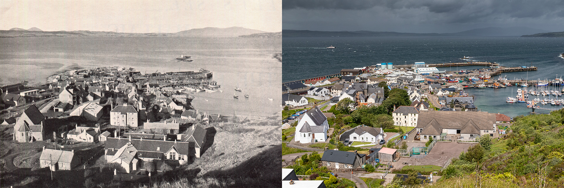
For this view entitled Mallaig and the Sound of Sleat, published in his booklet Let’s See Mallaig and the Road to the Isles, W.S Thomson had to make a real effort. Leaving his car on the main road from Arisaig, just before entering Mallaig, he scrambled up a steep hill. By going to such lengths, he was able to capture the fishery port in one shot, including the magical view north over the Sound of Sleat to the Isle of Skye.
By coincidence, this hill was picked in the 1970s to build a transmission mast to bring a proper radio and television signal to Mallaig. From the road, which is now the old road, I walk up the steep metalled track to the mast, 71 metres above sea level. To find the exact spot where Thomson stood 75 years ago, I have to descend slightly to a small platform covered with heather.
At the fore of the photograph is the school, the only one in Mallaig in the 1950s, now simply the Primary School (rebuilt in 1981). A new High School was built up the road in 1989.
Mary Michie (née Manson) says: ‘The photograph is very familiar to me. I attended that school. And my granny, Mary Atchinson, lived for a while in a bottom tenement in the three-storey building at the centre of the photograph. The private home in the bottom left is called Ghillie’s Cottage.’
Further down on the left lies St Columba’s Parish Church (Church of Scotland), perched on a crag above the old road. The church, built in 1903 to the designs of James Grewar Falconer, has buttressed walls and a gothic apse. A tiny part of the old road into Mallaig, which is called Annie’s Brae, is visible at the back of the church. Further down the road, on the same side, stands the West Highland Hotel, built after the Station Hotel burned down in 1927.
James Grewar Falconer was the son of William Falconer, estate overseer and his wife Jean Grewar and younger brother of Lake Falconer. The brothers founded their practice in Blairgowrie in the early 1880s. A branch office was opened in Fort William before 1900 by James Falconer and then another at 22 Alexandra Place, Oban, which became the main office and was later to be run by Lake Falconer junior.
Most of their practice was estate work, their buildings being in a lightweight harled idiom with half-timbered gables. James Falconer was in charge of the Fort William and Oban offices. Although ‘Who’s who in Architecture’ 1914 lists only Lake Junior at the Oban office, James Grewar Falconer continued to practice into the 1920s, though the office in Fort William may have been closed. In 1922 he made extensive additions to Meoble shooting lodge for Sir Berkeley Sheffield.
He died on 25 March 1928 at his home in Blairgowrie, Invergloy. He was married twice, first to Bessie McFarlane and then to Euphemia Henderson Douglas. His son who lived in Huntly survived him. – Source: Scottish Architects
On the opposite side of the road lies the Roman Catholic St Patrick’s church. This functional low-lying hall is typical of Reginald Fairlie’s design, erected in 1935. Further back, we can see the Community Centre, where the Mallaig Station engine shed stood in the past.
Reginald Norman Fairlie was born on 8 May 1850, the son of James Ogilvy Fairlie of Coodham and his wife, Elizabeth Constance Crawford and uncle of Reginald Francis Joseph Fairlie. He was educated at Trinity College, Glenalmond, and was articled as an architect but no details of his training are yet known.
Fairlie’s career as an architect is obscure. It is possible that he became an architect to undertake estate work but his father sold Coodham to Sir William Houldsworth in 1871 and his broathers employed Henry Walker at Myers Castle and Sir Rowand Anderson at Swallowgait, St Andrews. His only know work was the erection of a temporary iron church for the St James RC congregation at the Scores, St Andrews, replaced by his nephew in 1909.
Fairlie married Ada, daughter of Henry McLaren in June 1880. Like his brothers he settled in Fife, living at the Roundel, South Street, St Andrews. Ada died on 11 August 1913. They had one son, Norman Edwin Fairlie, born 17 March 1882 and educated at Radley. He was commissioned 2nd Lieutenant in the Argyll and Southern Highlanders at the outbreak of World War I and was killed in action on 21 October 1914. Fairlie died 5 December 1932. – Source: Scottish Architects
In the 1950s, Mallaig had two piers: the shorter fish pier and the railway and steamer pier. ‘The fish pier was extended in 1972,’ harbour master James “Pimmy” McLean explained (see below). He adds: ‘The same year, the fish sales hall was constructed. The railway steamer pier was upgraded and extended in 1986. Hebridean paddle steamers gave way to modern roll on – roll off (RoRo) ferries.’
Pimmy continues: ‘On the Point, a rocky and windswept part of Mallaig, on the seaward side of the railway pier, kippering sheds were built. About thirty wooden huts accommodated migrant fish workers, the so-called herring girls, who gutted and salted the herring in teams of three.’ That is why this corner of the village was nicknamed Chinatown.
‘One of the biggest fish houses was the National Canners,’ Pimmy adds: ‘Other companies were Samson Fish Curers, Macrae Ltd and Henderson & Son. There were at least seven, and all of them, but one, are gone. The Lawries still produce the famous oak-smoked Mallaig kippers.’
George “Jaffy” Lawrie formed the original family business of Lawrie & Sons in 1944 before passing on the craft to his sons who later built the smokehouse that we still use to this day. Now, Jaffy’s grandson, Jeff, carries and upholds the secrets and processes which make the deliciously smoked fish that we’re known for, whilst passing on his knowledge to his own children in preparation for the future. – Source: Jaffy’s Smokehouse
There was a significant change in the harbour in 1998 when a third pier, the outer breakwater, was constructed. A modern ice factory, an oil storage and new buildings took the place of the old kippering sheds.
The remake was taken on a windy day, with a choppy Sound of Sleat, and a CalMac ferry rounding the Sgeir Dhearg en route to Mallaig. In the 20th century, two ships were stranded on these rocks: in 1914, the Wallflower, a 24-metre steam drifter, a vessel frequently used in the Scottish coastal fishing industry, and in 1978, the Peggy, a 14-metre Norwegian fishing boat.
In the calm and azure waters of the harbour, sailing boats sit along the pontoon at the Marina Centre, which was completed in 2016. It is the latest development in the history of Mallaig, which 200 years ago was known as An Garbh Chriochan, The Rough Bounds.
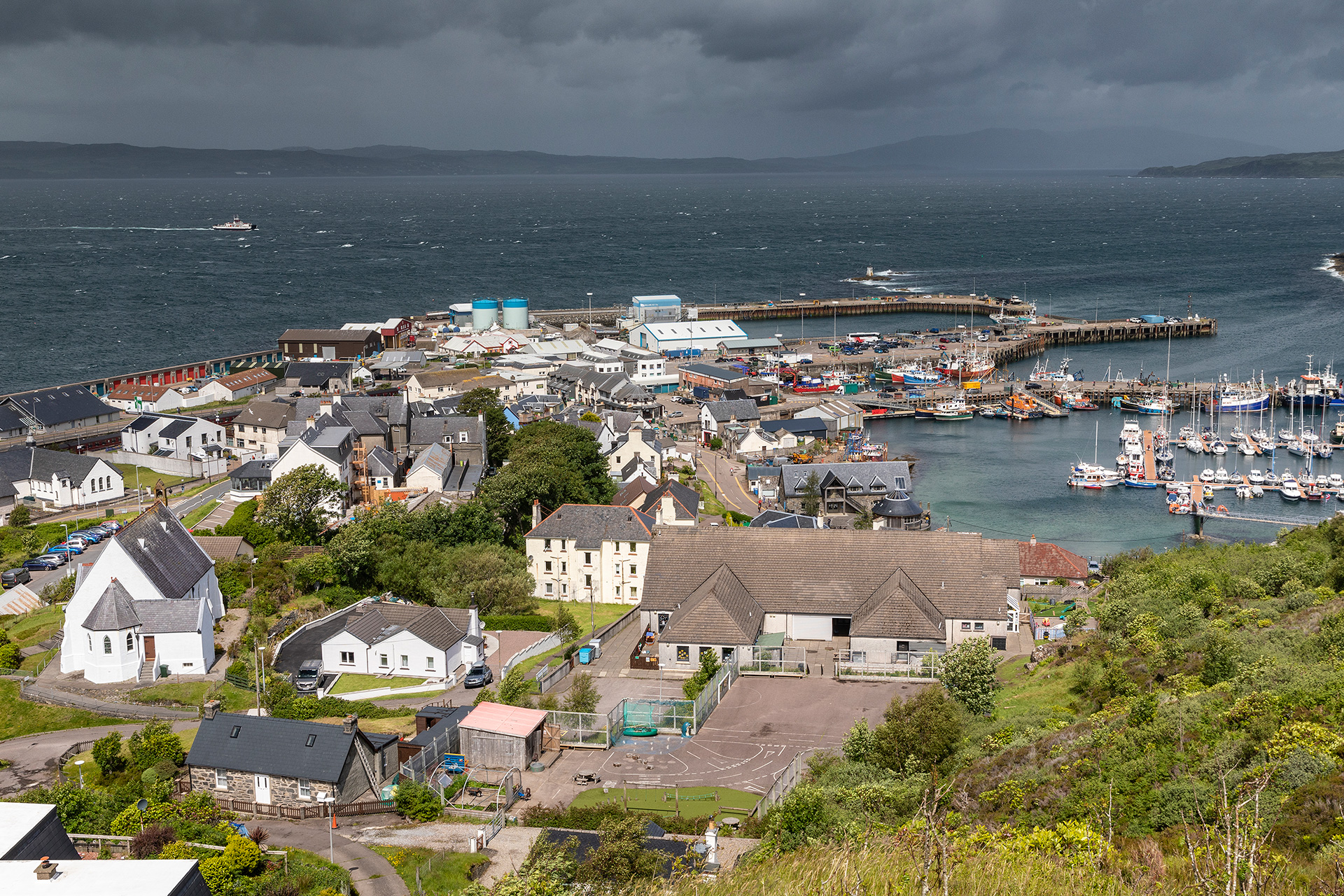
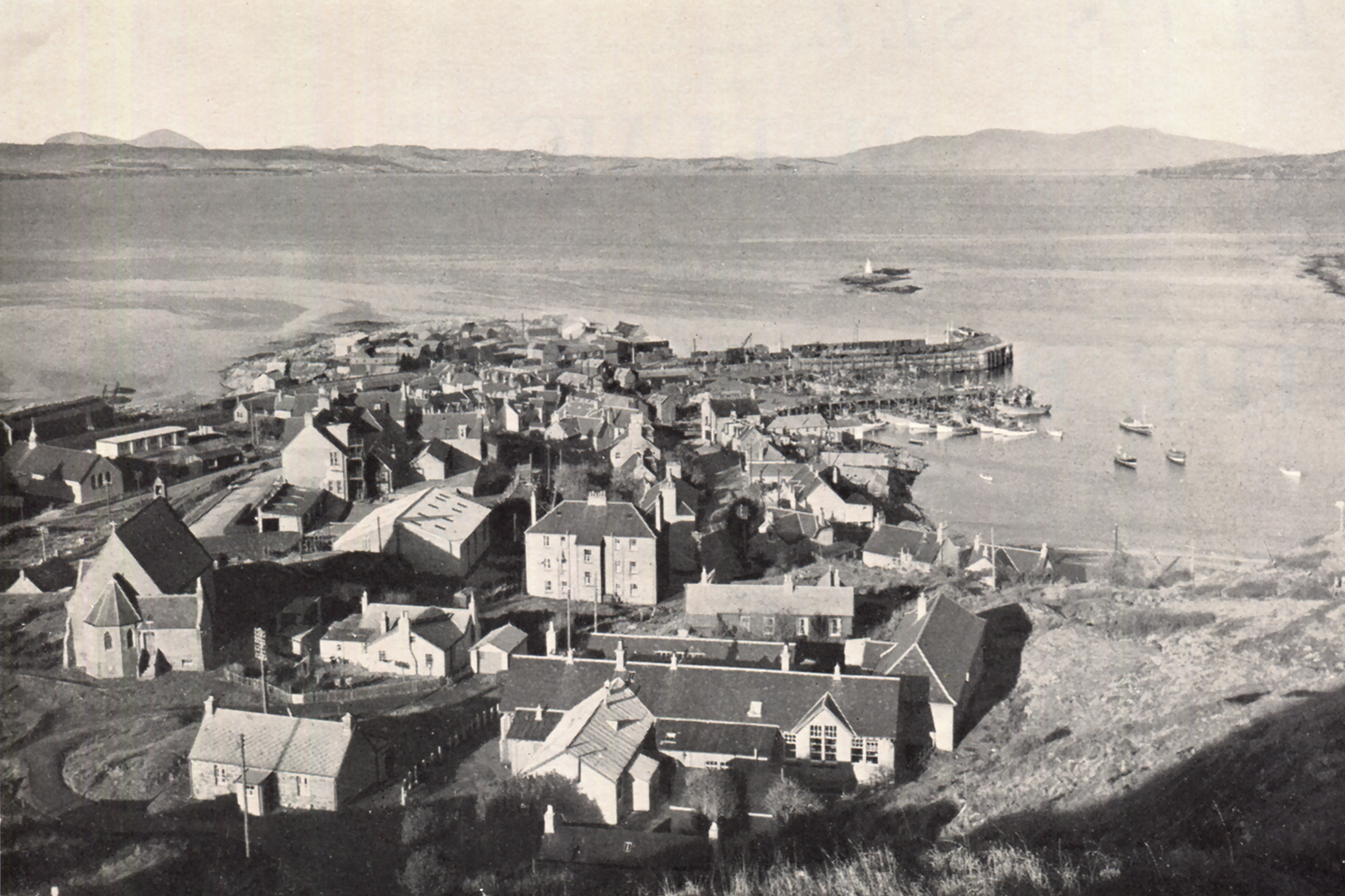
Move the slider to discover what changed.
Then (left) – Late 1940s © W.S. Thomson – Mallaig and the Sound of Sleat. Published in Let’s See Mallaig and the Road to the Isles (William S. Thomson, Corpach/Fort William, [Early 1950s]), p. 2.
Now (right) – June 2022 © Estelle Slegers Helsen – Mallaig village with the Marina, the Harbour and the Sound of Sleat. Published in Travel in Time. Lochaber, Scotland (New Traces, Waltham on the Wolds, 2022), p. 23.
From where I have taken the remake.

Harbour
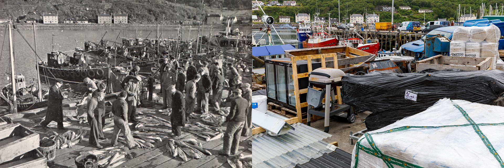
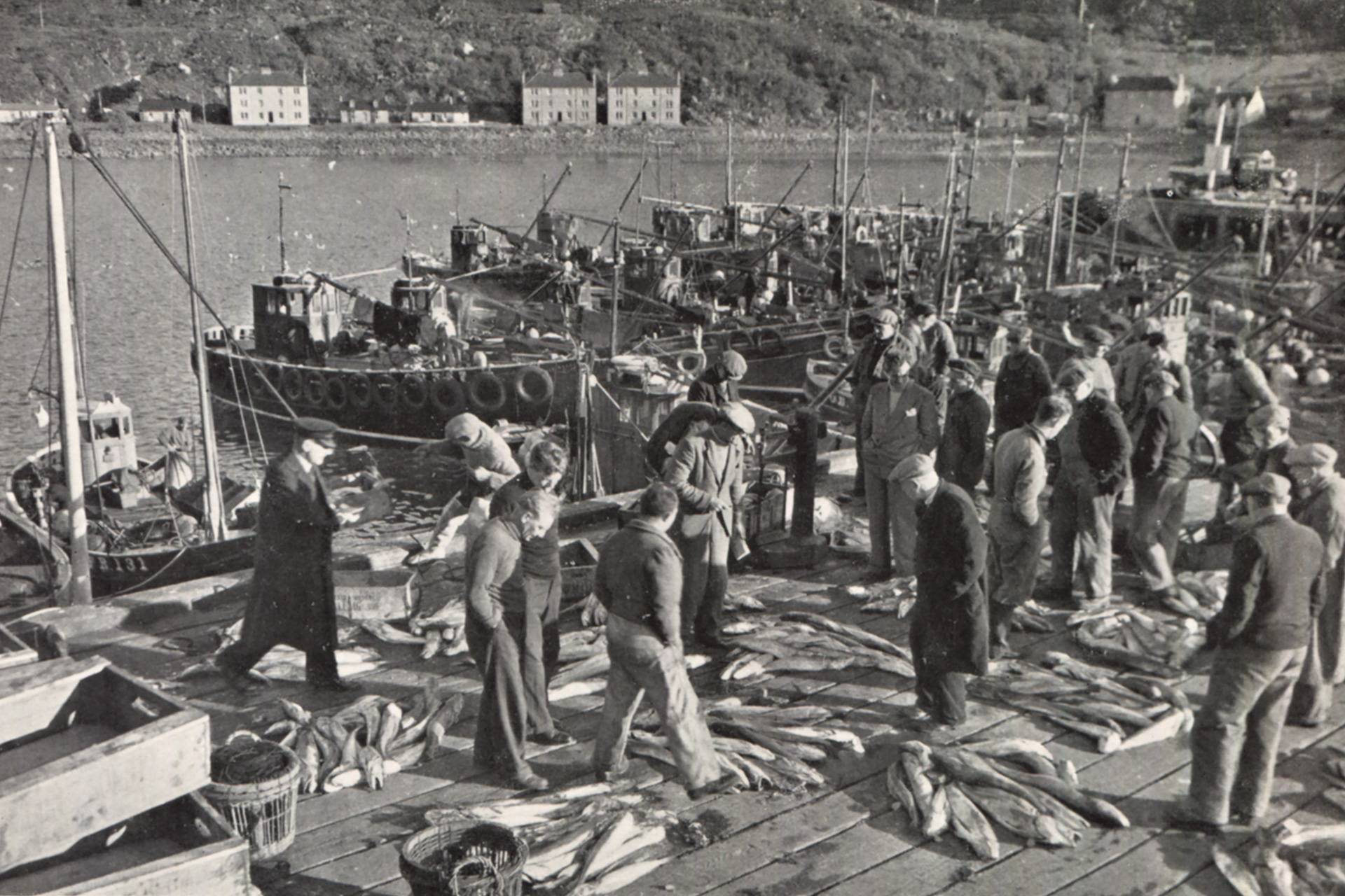
W.S. Thomson’s photograph Auctioning the night’s catch at Mallaig Pier captured in the late 1940s, is an unusual image published in his booklet Let’s See Mallaig and the Road to the Isles. As a landscape photographer, he focused on the glens, lochs, hills, mountains and clouds and avoided people in his frames. However, this photograph including two dozen people perfectly concludes the photo journey from Glenfinnan to Mallaig, depicting Mallaig as a busy fishing port.
‘As a village, Mallaig is a relatively recent creation,’ explains Malcolm Poole, the Mallaig Heritage Centre curator. ‘In the 1840s, Lord Lovat, the owner of North Morar Estate, divided the farm of Mallaigvaig into seventeen parcels of land and encouraged his tenants to move to the western part of the peninsula to make a living from fishing.’ Fishing was a hazardous business in the 19th century. Despite this, by 1851, more than a hundred people had settled on the rough and windy plots of Mallaig, which became the largest settlement on the peninsula.
‘The steady growth of Mallaig as a harbour began with the building of the first pier in 1846 by Lord Lovat,’ adds harbour master James “Pimmy” McLean. ‘Ever since, Mallaig has been synonymous with fishing, particularly with herring fishing on the west coast and was in fact the largest herring port in Europe in the 1960s and 70s.’
In the introduction to Let’s See Mallaig and the Road to the Isles, Wendy Wood describes the village as a place dominated by gulls: ‘At first glance, Mallaig might be judged ugly and uninteresting and mainly populated by gulls. Every islet is white with gulls, every gable, fence, flagstaff and roof has its decoration of portly white seabirds.’
She continues: ‘Mallaig is mainly a harbour. In that basin lie boats of all sorts and sizes that come and go like buses from a bus terminus. Boats being repaired, re-painted, even a-building. Boats ashore, boats afloat, from dinghies and fishing smacks [a traditional fishing boat with sails] to MacBrayne’s steamers…’
Thomson has captured a busy morning on the harbour quay. In the middle are the local herring boats. The Mansons, a fishing family, owned five of them. From her recollection, Mary Michie (née Manson) points out a few family members and other people. ‘The man on the left is Mr Kennedy, who worked at the railway. I think my father is fourth from the left in the darker jersey, speaking to Bruce Watt. Further to the right, in front with the longer dark coat, is uncle Jim Addison, and behind, I recognise uncle Jim Manson and my cousin Jimmy Manson.’
The image of the harbour, mainly built of wood, completely changed in 1972. The fish pier on the right, hidden behind more than a dozen fishing boats, was extended with a concrete structure being added to the underlying old pier. More concrete was used to add height to the wooden harbour floor and to extend it 8 feet further out. A fish sales hall was built, putting an end to open-air trading.
By the mid-1970s, Mallaig had plunged into darkness. Pimmy: ‘Fish stocks suffered from years of overfishing, and a four-year ban on herring fishing was imposed. It was a struggle to get the markets back. The Mallaig fleet turned to alternative catches, such as mackerel and whitefish. Today, we are a leading port for prawn landings on the West Coast.’
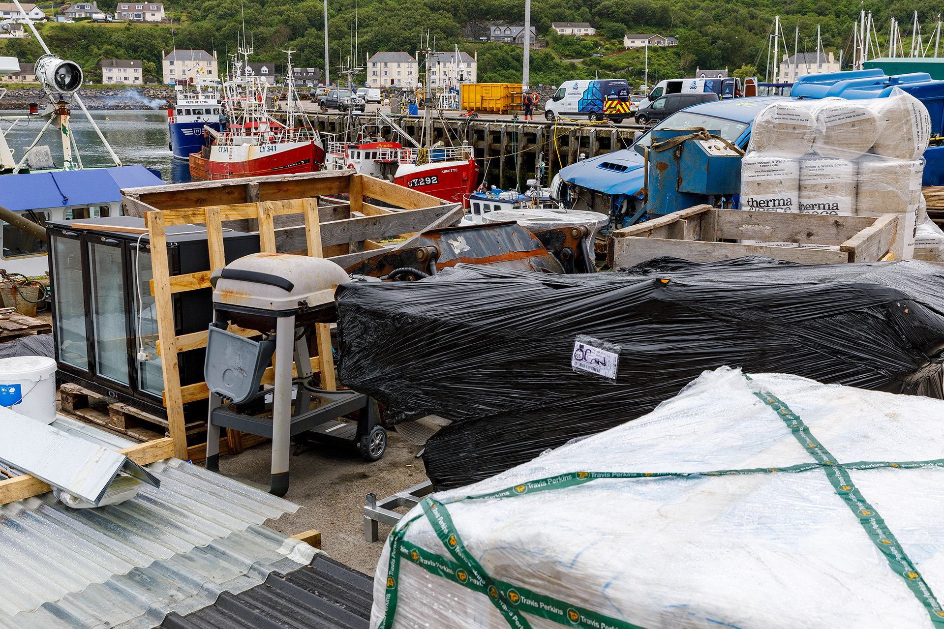
From his first-floor office, Pimmy points to where Thomson took the photograph. The remaining reference points are the buildings in the background along East Bay. The houses and three blocks of flats were built in the 1920s when the road to Mallaigvaig was widened.
(Read further after the slider and dissolve)
Move the slider to discover what changed.
Then (left) – Late 1940s © W.S. Thomson – Auctioning the night’s catch at Mallaig Pier. Published in Let’s See Mallaig and the Road to the Isles (William S. Thomson, Corpach/Fort William, [Early 1950s]), p. 21.
Now (right) – June 2022 © Estelle Slegers Helsen – Mallaig Harbour with the view towards East Bay. Published in Travel in Time. Lochaber, Scotland (New Traces, Waltham on the Wolds, 2022), p. 25.
There were more than fifty locally owned fishing boats in the heydays, and now there are five. All the goods you see at the forefront are being temporarily stored on the quay as they are moved to or from the small isles like Rum or Eigg and Inverie on the Knoydart peninsula across Loch Nevis.
As I walk along the harbour and go into the neighbouring village streets, seagulls remain part of the scenery; although less distinct than they used to be. More prominent are the tourists from Fort William who have come on the trendy Jacobite train to Mallaig. During the day, they fill the coffee shops, restaurants and souvenir shops. Sitting on the benches and low walls, they eat fish and chips or ice cream. And once in a while, amidst general hilarity, a beady-eyed seagull darts down and takes a bite from the meal of a distracted tourist.
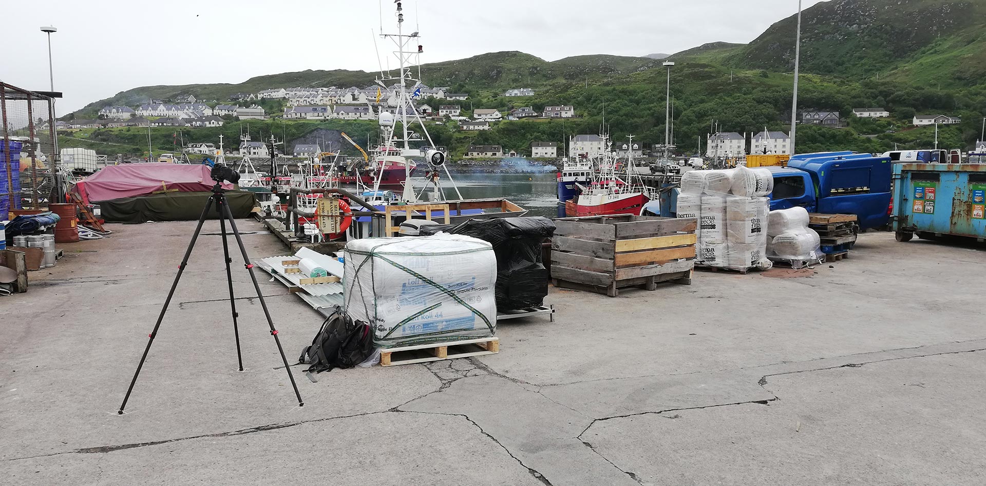
From where I have taken the remake.
Links
- Mallaig Harbour History – Mallaig Harbour Authority
- Mallaig History – Mallaig History Centre

Travel in Time – Lochaber Series is supported by the West Highland Museum and the Year of Stories 2022 Community Stories Fund.
Estelle has published a 64-page book with 30 side-by-side then-and-now pictures, which you can find in local shops or buy online. More information available here.
